Tuesday, September 27, 2016

Oscillator Comments Holding Area

A family of random walks is shown below - as would be obtained by "integrating" coin flips e.g. a head you move up, a tail you move down. Graph shows progress after 100 flips. The walk was repeated eight times to create the graphic below.


A "blizzard" of trials below illustrate a zero ensemble mean and a variance that grows with time.


From DSTG "Bayesian Methods..." book.


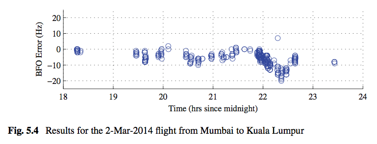
Statistical estimates from manual (and tedious) data extraction from the above figure:

mean ~ -6.5 Hz  standard deviation ~ 5.3 Hz

It is important to note that the flight time from Mumbai to Kuala Lumpur is a bit over five hours, so that figure 5.4 above represents essentially all of the BFO data from that particular flight. It is also important to note that statistics from all the flights of 9M-MRO looked at by the DSTG (some 20 flights in all) and summarized in Table 5.1 have an in-flight standard deviation of 5.5 Hz when outliers are included. See table 5.1 below. So, what makes figure 5.4 unique is not the standard deviation, but the mean of -6.5 Hz relative to an ensemble mean much closer to zero.

In fact, the DSTG comments relative to Figure 5.4 have more to do with the deviation from a mean close to zero and a structured bias. No comment was made relative to the standard deviation which leads one to the same conclusion above - that it was not considered abnormal.

"The bias used for the plot was obtained by analysing BFO measurements while the aircraft was on the tarmac. The residual error is clearly not zero-mean, and the mean varies with time."  


In fact, if one were to generate representative statistics for the BFO error for 20 flights the data might very well resemble the data below.


The figure above strongly suggests that most previous analytics with highly constrained BFO errors may be suspect relative to terminal accuracy, and that the DSTG is probably correct in modeling flight paths with an emphasis on ground speed, track constraints, and BTO residuals.

The recent work of Iannello and Godfrey is among the first produced by "mainstream" analysts to relax the notion of a highly constrained BFO.

Iannello and Godfrey

See also the link below which supports the DSTG use of a nominal BFO sigma of 5Hz when computing the range of speeds and tracks at 19:40.

Midflight Speed

Afterthought

None of the above presents a challenge relative to the notion of the plane tracking South after the FMT or the hypotheses of a rapid rate of descent at 00:19. What it does challenge is the notion of accurately predicting where the plane actually went, and where the rapid descent took place.


Tuesday, September 20, 2016

Funny Stuff

Screen capture below from the "comments" section of an MH370 article by Byron Bailey which appeared today (9/21/16 Aussie time) in "The Australian".

Search bosses ‘in a bit of a pickle’ as MH370 mystery deepens

The article is behind a paywall so I will not post a link. Interested people can figure it out.


It would seem, even based on this small sample size, that the Australian people have had enough. I agree with the commenters. The entire search has been embarrassingly mismanaged. I find myself in agreement with William. The ATSB has obviously hitched their wagon to the wrong ponies.

Wednesday, September 14, 2016

Alternate MH370 Flight Path

Motivated by the coordinates found on Shah's simulator drive, Iannello and Godrey created a flight path using McMurdo Station in Antartica as a destination point. That work can be found here:

Iannello and Godrey

An alternative possibility is a flight path using Cocos Island as a waypoint initially. After flying toward Cocos the plane, in this model, was redirected toward Exmouth, AU. The flight path from 19:40 to 00:11 is shown in Goggle Earth below (green path). The path to the Cocos is almost identical to the path to McMurdo Station. No explanation is offered for the initial path to Cocos or for the subsequent selection of Exmouth as a destination. These paths may simply have been convenient selections in the onboard waypoint menu, and suited Shah's purpose at the time.


Supporting data in spreadsheet form is provided below:


Note: Not everything in this blog is linked in the public domain, however, that does not mean the information is meant to be private. I just regard it in the category of personal notes or a personal diary. It is a convenient way for me to keep these "research ramblings" organized and not lose them in a bunch of loose papers as I am prone to do. Feel free to use anything here in any manner you wish.


Sunday, September 4, 2016

Indonesian Radar Coverage (Lhokseumawe)

The graphic below shows the coverage (red circle) of the Thomson-CSF TRS-2215 radar located in Indonesia at Lhokseumawe.


It is hard to reconcile how the Indonesia radar did not see MH370 when the flight path was in view of this radar from Pulau Pinang all the way to beyond the final primary radar coverage at Butterworth RMAFB located near Pulau Pinang.  The overlap between the Indonesian radar and the Butterworth radar is significant, and the Malays claim the Butterworth radar tracked the plane for 200nm into the Malacca Strait. MH370 literally flew right past the Indonesian radar site.

The "presumed final major turn" location is not relevant to this discussion.

Davey, Gordon, et.al. BFO Data

Davey, Gordon, et. al. all members of The Australian Defense Science and Technology Group have published a book, Bayesian Methods in the Search for MH370, Springer 2016. The book was published as Open Access, so I am allowed to post the "duplication" below from page 30 of the book.

This book is published open access.
Open Access This book is distributed under the terms of the Creative Commons Attribution- NonCommercial 4.0 International License (http://creativecommons.org/licenses/by-nc/4.0/), which per- mits any noncommercial use, duplication, adaptation, distribution and reproduction in any medium or format, as long as you give appropriate credit to the original author(s) and the source, a link is provided to the Creative Commons license and any changes made are indicated.


The material describes the BFO error, difference between logged and calculated BFO, on a test flight described in the text accompanying the figure.

//////////////////////////////////////////////////////////////////////////////////////////////////////////////////////////////////////////////////


//////////////////////////////////////////////////////////////////////////////////////////////////////////////////////////////////////////////////


The significance of the above data is two-fold. First there are BFO errors on the order of 20Hz, and second the error is one-sided. Previously Inmarsat suggested BFO accuracy should not be assumed to be better than 7Hz (not clear if this peak, or one sigma). Analysts have been synthesizing candidate paths with low single digit BFO errors. This new data opens up the range of 7th arc solutions rather dramatically.